
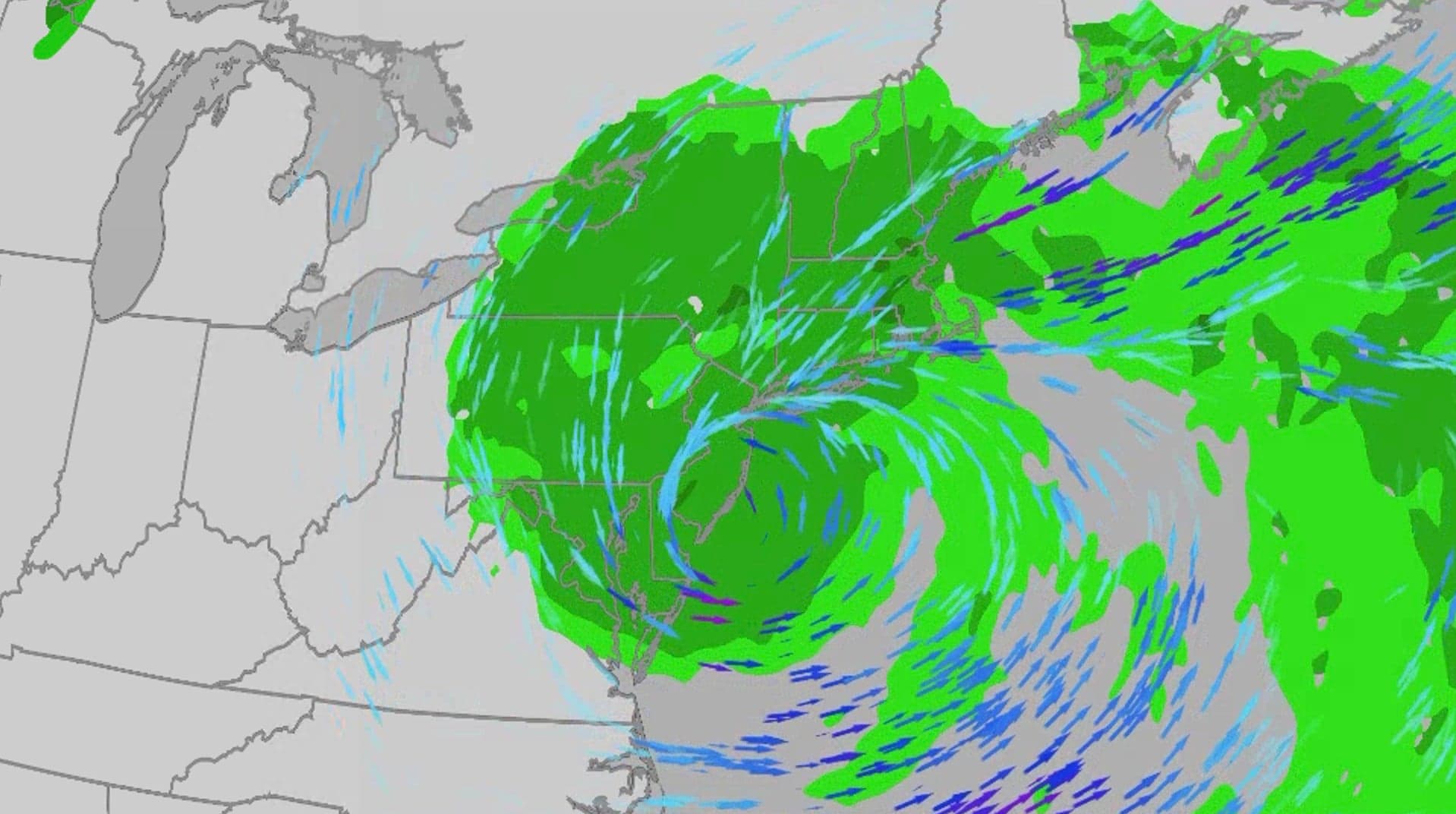
An early-season nor'easter is currently hammering the Northeast and mid-Atlantic, with a slow-moving storm system set to impact the East Coast through Monday. Residents from North Carolina to New England are facing a combination of coastal flooding, high surf, and gusty winds, a situation exacerbated by a full moon this weekend which amplifies tidal risks.
What’s Happening Now
The storm is lashing the region with significant weather impacts. The National Weather Service has issued warnings for major inundation along the Jersey Shore and North Carolina's northern Outer Banks, while Massachusetts faces moderate coastal flooding. The interplay between the storm's surge and the astronomical tides creates dangerous conditions for low-lying coastal areas.

Forecast Timeline
- Sunday: The nor'easter will meander just offshore, occasionally dipping onshore. Expect lingering rain across the Northeast, particularly in southern New England. The heaviest rainfall is projected from southern New Jersey to northern Massachusetts, covering New York City and Boston. Strong winds may persist into the morning before easing, but coastal flooding remains a threat during high tides.
- Monday: The weakened storm will remain near or just off the coast. Rain showers and gusty winds will continue over New England, Long Island, and the Hudson Valley, including NYC. While Boston expects heavier rain than previous days, it won't match the intensity of Saturday and Sunday.

Potential Impacts
Coastal Flooding: Warnings have been issued for Atlantic City, Long Island, Norfolk, Ocean City, downtown Boston, Cape Cod, Martha's Vineyard, and Nantucket. The most severe flooding is expected in the Virginia Tidewater, Chesapeake Bay, and Delaware Bay, where water levels could be 2-4 feet higher than normal at high tide. Long Island’s south and east bays face up to 3 feet of inundation. Beach erosion is also anticipated to reach extreme levels in some areas.

Rain: Fortunately, rainfall is spread out over several days rather than hitting in a single deluge, reducing widespread flood risks to localized urban trouble spots. However, rain will still contribute to coastal flooding during high tides through Sunday.

Winds: High wind warnings are active for parts of the Jersey Shore, Long Island, and eastern Connecticut, with gusts potentially reaching 60 mph on Sunday. Soaked ground and leaves increase the risk of tree damage and power outages. Sporadic gusts of 40-50 mph are possible from Virginia to coastal New England, posing similar risks.

Travel Disruptions
Travelers should anticipate significant disruptions:
- Airports: Delays are likely at Boston-Logan and all three major NYC airports (JFK, LaGuardia, Newark) through the weekend.
- Roads: The I-95 corridor will be slick, leading to significant delays, especially around NFL games. Downed trees and flash flooding are possible in southeast New England, the NYC metro, and New Jersey. Avoid coastal areas from northern North Carolina to southeast New England during high tides.
Recent Recap
Since Wednesday, gusts have topped 40 mph along the coast from Massachusetts to Virginia, piling up ocean water and causing minor to moderate flooding. By Thursday evening, water levels reached major flood stage in areas like Norfolk and Smithfield, Virginia. Notably, a 16-mile stretch of North Carolina Highway 12 on the Outer Banks was closed due to ocean overwash.






Comments
No comments yet
Be the first to share your thoughts and start the conversation!